Comprehensive Drilling Program Design for Nickel Exploration
Exploring nickel deposits requires a strategic drilling program design that maximizes efficiency and accuracy. Nickel, a versatile metal used in various industries, is in high demand for its corrosion resistance and magnetic properties. A comprehensive drilling plan tailored for nickel exploration is crucial for identifying viable deposits and optimizing resource extraction.
Designing a drilling program involves meticulous planning, including site selection, drilling techniques, and data analysis. By utilizing cutting-edge technologies such as electromagnetic surveys and geochemical analysis, geologists can pinpoint potential nickel hotspots with precision. The strategic layout of drill holes and sampling methods play a vital role in assessing the economic viability of a nickel deposit.
Furthermore, an effective drilling program for nickel exploration considers environmental impact mitigation and regulatory compliance. Companies must adhere to stringent guidelines to minimize ecological disturbances and ensure sustainable mining practices. By integrating environmental awareness with innovative drilling strategies, stakeholders can responsibly explore and extract nickel resources.
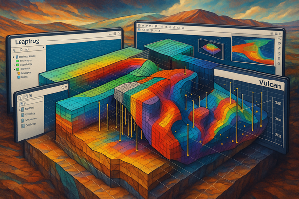
Advanced 3D Geological Modeling Techniques Using Leapfrog, Surpac, and Vulcan
Key Insights and Strategies
For advanced 3D geological modeling, a blend of specialized software tools like Leapfrog, Surpac, and Vulcan can revolutionize the modeling process. Leapfrog offers intuitive modeling capabilities, Surpac enables detailed surface designs, and Vulcan excels in complex geological interpretations.
Combining these tools provides a comprehensive approach to modeling, from data import to visualization, aiding in accurate resource estimation and mine planning.
Step-by-Step Guide
- Step 1: Import geological data into Leapfrog to build a preliminary 3D model.
- Step 2: Refine the model by incorporating structural data using Surpac for enhanced geological accuracy.
- Step 3: Utilize Vulcan for in-depth interpretations and further refining the model for precise insights.
- Step 4: Implement advanced visualization techniques across all platforms to streamline communication and decision-making processes.
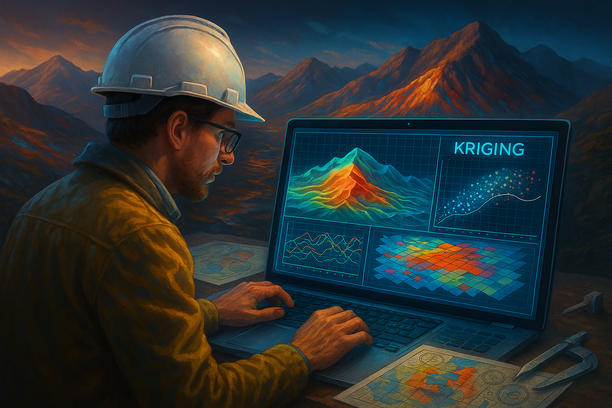
Optimizing Kriging Methods for Accurate Resource Estimation
When it comes to accurate resource estimation in fields such as geology, mining, and environmental studies, optimizing Kriging methods is crucial. Kriging is a powerful interpolation technique that relies on statistical analysis to estimate values at unmeasured locations based on nearby sampled points.
Enhancing Neighborhood Selection
One key aspect to optimize Kriging methods is to carefully select the neighborhood for interpolation. Ensuring that the neighboring points are relevant and representative of the local geological characteristics can significantly enhance the accuracy of resource estimation.
Variogram Analysis Refinement
Another critical factor in optimizing Kriging methods is refining the variogram analysis. Variograms help in understanding spatial variability, and by fine-tuning the variogram model to better fit the data characteristics, more accurate estimations can be achieved.
Cross-Validation Techniques
Utilizing cross-validation techniques is essential in optimizing Kriging methods. Cross-validation helps assess the performance of the interpolation model by testing its accuracy on independent data subsets, allowing for adjustments and improvements to enhance the final resource estimates.
Regular Updating of Data
Regularly updating the dataset used for Kriging is crucial for accurate resource estimation. As new data becomes available or the understanding of the area improves, incorporating updated information into the interpolation process ensures that the estimations reflect the most current insights.
Quality Assurance Checks
Implementing rigorous quality assurance checks throughout the Kriging process is vital. Validating the input data, monitoring the interpolation results, and comparing the estimations with ground-truth data can help detect and rectify any errors or inconsistencies, leading to more accurate resource estimates.

Implementing International Standards for Resource Classification and Validation
Implementing international standards for resource classification and validation is essential for ensuring consistency and transparency in reporting across different industries and regions. By adhering to recognized standards such as the United Nations Framework Classification for Fossil Energy and Mineral Reserves and Resources, companies can classify and validate their resources in a way that is universally understood and accepted.
These standards provide a common language that enables stakeholders to compare resource data accurately, facilitating investment decisions and fostering trust among investors, regulatory bodies, and the public. Following international resource classification and validation standards also helps companies demonstrate their commitment to best practices, sustainability, and responsible resource management.


